
Sandy Point European Settlers
European Arrival
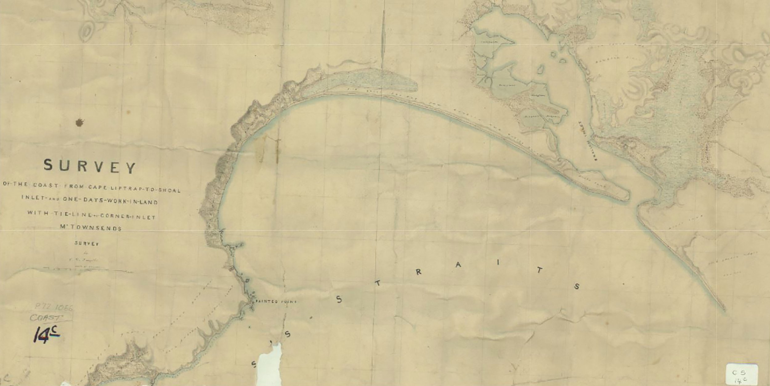
Sealers and whalers came to the area in the early 1800s and the coastline was officially surveyed in 1841 by Thomas Townsend. George Smythe then built upon Townsend’s survey and mapped the area in about 1847. Smythe was also the first to take up the run at Cape Liptrap
The Pastoralist era and the Sandy Point Run

The pastoral runs of South Gippsland and the County of Buln Buln taken from: Spreadborough, R and Anderson, H. Victorian squatters, 1893
The Sandy Point run consisted of an area of about 15,000 acres extending from the tip of the Sandy Point spit, then following the Waratah Bay coastline as far as Cooks Creek. The boundary then turned inland in a northerly direction for about 5 km before tracking towards the northwestern tip of Shallow Inlet near Dividing Creek. The boundary then skirted around Shallow Inlet back to the mouth of the Inlet.
James Dobson was the first licensee of the Sandy Point Run in c1856. In 1864 it was taken up by James Flanner, but rapidly changed hands, to John Elliot in 1865, and in 1867 to David Fraser. Shire records show Dobson was the first ratepayer in 1863 and although he didn’t live there himself, records show that there was a two-room house on the run on the site where ‘Doonagatha’ now stands. Fraser then likely extended the original house and he and his wife, Mary Kydd Findlay, raised their family of 5 children there. Vi Pilkington records in her booklet “South of the Dividing Creek” (available from the Foster Museum) that when the house needed repairs in 1898, newspapers were found in the walls which dated back to the 1860s.

David and Mary Fraser and Family (John (b.1869), Norman (b.1871), Annie (b.1874), Douglas (b.1878) and Jessie (b.1880)) c1888 (courtesy of Melinda Fear)
The Selectors

Remoteness and the lack of reliable transport delayed permanent settlement in the area, but in the 1880s the Sandy Point Run was broken up into approximately 800-acre blocks which were offered to the public. In order to ensure equity and affordability, the legislative regime of the time required the selector initially to rent the land under licence. If improvements were made (e.g. fencing, clearing and drainage) and rent paid, the licensee could apply to have the title converted to a leasehold and later apply to purchase the freehold. David Fraser had previously purchased 200 acres of land around his homestead (see A1 on the map at left) under a pre-emptive right that was offered to pastoralists in the 1860s. In addition, he leased Crown Allotment 22 as well as continuing to pay a licence fee for remaining blocks of land that had not yet been selected. Fraser fell victim to the crash in the 1890s and these properties passed to the Bank of Australia.
With the settlement at Fish Creek beginning in 1884 and the building of the South Gippsland railway in 1891, cattle fattening and dairying became more viable and consequently, land was more sought after. Samuel Hays Lowry (1826-1899) was one of the first to take up land in the Sandy Point area. He successfully applied and paid the fees for Crown Allotments 15,16,17, 19 and 20 on behalf of five of his children. After arriving in Australia, he initially settled in central Victoria but, with his wife Edith Williamson moved to Fish Creek in the 1880s. He operated the postal delivery service carrying the post from Foster to Sandy Point and Waratah. Unfortunately, none of the Lowry children were successful in their endeavours to become farmers. The two girls married and settled elsewhere. The Map of the Sandy Point area from a c. 1885 map of the County of Buln Buln showing the break-up of the Sandy Point Run into smaller blocks (each approx. 800 acres) (VPRS 8168 Historic Plan Collection. PROV) land was poor, some of it was swampy and much of it covered in native vegetation. Gradually the rental payments went into arrears and the land was returned to the Crown. Thomas Radcliff took over the leases of CA 16 and 17 from Samuel Lowry in 1890 and these were farmed by his two sons Thomas and Joe. Joe had a reputation as having a bad temper and the brothers did not get on. In 1895 there was a fight between the two which resulted in Joe’s death. Thomas (junior) and a farm hand James Hannan were arrested but later released after a Magisterial Inquest established that Joe had died as a result of the accidental firing of a shotgun after he had thrown it across the floor. The leases were transferred in 1898 to Donald Cameron and Alex Smith. Sandham (Dan) and Fred Pilkington from County Clare in Ireland arrived in the area in 1898 and they purchased David Fraser’s homestead and 200 acres. They also took over the lease of Crown Allotment 20.

The Pilkington family and others on the beach c1921 (Photo courtesy of the Pilkington family)

‘Ennisvale’ (Photo courtesy of the Pilkington Family)
Charles arrived later after leaving the army, and between them, the brothers leased and later obtained the freehold of other Crown Allotments in the Sandy Point area (including 21E and 21F (formerly 21A), 22B, 22C, 22D). Charles Pilkington and his wife Evelyn Dewar built ‘Ennisvale’ named after Ennis, the principal city in County Clare Ireland where the Pilkington brothers were born. The house stood on the north side of Sandy Point Road near the intersection with Ennisvale Avenue.
Fred Pilkington and his wife Mollie (Mary Hastings Moore) named their property ‘Gyndahnook’ whilst Dan Pilkington and his wife Rosa Robertson McFarlane took over the block on which the original homestead had stood, and built their own house, calling it Doonagatha.


Photo showing the extent of the seawall along the shore of Shallow Inlet protecting farming land from inundation from tidal flooding.
Many Pilkington descendants remain in the Sandy Point area today and still own the same properties.
A cousin of the Pilkingtons, Charlie Griffin took up Crown Allotment 22A and constructed a weatherboard two-roomed house with a verandah at the front and back. He married Lily in 1913 and they called the property ‘Blue Look Out’. It is now called Blue Meadows.
The Griffin land was subject to constant tidal flooding and Charlie built a sea wall using the meagre tools and equipment available at the time to manage this. However, the sea wall was breached on several occasions and the pastures inundated with salt water. The devastating effect of this eventually forced the couple to give up their lease in 1926 and leave the area. Eventually, in 1960 the problem was overcome when John Bowron built a new, bigger sea wall using a dragline. By 1970 the sea wall had been considerably strengthened and extended and it now protects most of the land south of the southern shore of Shallow Inlet.
Charlie Griffin’s sister, Kathleen, who had been a nurse in London, arrived in the area in 1901 and selected Crown Allotment 21. She called the property "Loch Shallow" and she worked it alone, clearing the land and building a hut. She raised turkeys that she drove along the beach to Waratah (now South Walkerville) to sell. After a few years she sold the land and returned to Ireland.
Home | History of Sandy Point | Traditional Owners | European Settlers | Settlement at Shallow Inlet | Early Settler Life | Township of Sandy Point